


Lat Long Calc
وصف لـLat Long Calc
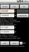
Lat Long Calc is a GPS tool that converts latitude/longitude coordinates to different formats and calculates distance and direction between two points. This is the free version. For more features look for Lat Long Calc Pro.
** If you find a bug, e-mail me and I will fix it. **
Of particular use in Search and Rescue (SAR) & GIS where conversion between different formats is needed.
Also useful in Geocaching, surveying or anything where you need to convert coordinates between formats.
Please contact me at cruthuservices@gmail.com for help before rating poorly.
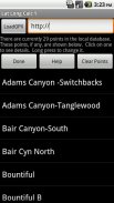
Supports DD.DDD, DD MM.MMM, DD MM SS.SSS, UTM and Maidenhead Locator. Can load points from a GPX and/or save points in local DB for later use.
Maidenhead Locator (4 or 6 digit) is useful for Ham (Amateur) Radio contacts or contesting.
Can use internal GPS to get current position which can also be saved to a local DB.
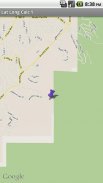
Includes mapping support. See your positions on a map. Options to use internal rendered Google Maps or external map provider such as Google Maps, or other map programs.
Long click on coordinate results to show map. Read help for more details.
Does not share any information. Internet access is for downloading your specified GPX file. GPS is only used if you select it.
Now has batter support for small screen devices.
Note: Mapping support requires Google Maps be installed.
اللات طويل احسب هو أداة GPS الذي يحول خط العرض / خط الطول تنسق الى صيغ مختلفة وبحساب المسافة والاتجاه بين نقطتين. هذه هي النسخة المجانية. لمزيد من ميزات بحث عن اللات طويل احسب برو.
** إذا وجدت علة، والبريد الالكتروني لي وأنا سوف إصلاحه. **
استخدام معين في البحث والإنقاذ (SAR) ونظم المعلومات الجغرافية التي تحتاج إلى التحويل بين صيغ مختلفة.
من المفيد أيضا في غيوكاشينغ، والمسح أو أي شيء حيث كنت في حاجة لتحويل الإحداثيات بين الأشكال.
الرجاء الاتصال بي في cruthuservices@gmail.com للمساعدة قبل تقييم سيئة.
يدعم DD.DDD، DD MM.MMM، DD MM SS.SSS، UTM وغشاء البكارة محدد. يمكن تحميل نقاط من GPX و / أو حفظ نقطة في DB المحلي لاستخدامها لاحقا.
بكارة محدد (4 أو 6 أرقام) مفيد لحام الاتصالات (هواة) راديو أو الطعن.
يمكن استخدام نظام تحديد المواقع الداخلية للحصول على الوضع الحالي والتي يمكن أيضا أن يخلص إلى DB المحلي.
ويشمل الدعم رسم الخرائط. نرى مواقفكم على الخريطة. خيارات لاستخدام خرائط جوجل أصدرت الداخلية أو مزود خريطة خارجي مثل خرائط جوجل، أو البرامج خريطة أخرى.
انقر طويلة على تنسيق النتائج لتظهر الخريطة. قراءة مساعدة لمزيد من التفاصيل.
لا تشارك أي من المعلومات. الوصول إلى الإنترنت لتحميل ملف GPX المحددة الخاصة بك. يستخدم نظام تحديد المواقع فقط إذا قمت بتحديد ذلك.
لديها الآن الدعم الخليط لأجهزة الشاشة الصغيرة.
ملاحظة: يتطلب دعم رسم الخرائط تركيبها خرائط جوجل.
Lat Long Calc - إصدار 2.0.0
(21-06-2018)Lat Long Calc - معلومات APK
نُسخة APK: 2.0.0الحزمة: com.cruthu.latlongcalc1آخر إصدار من Lat Long Calc
نُسخ أخرى


 3.55
3.55تطبيقات من الفئة نفسها


قد يعجبك أيضًا...


